


Baou de saint jeannet

Arnaud Stévenard
User
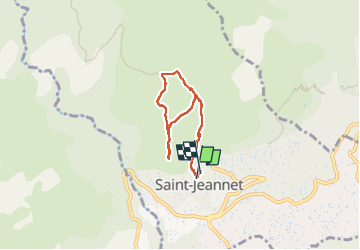

Length
6.1 km

Max alt
810 m

Uphill gradient
398 m
Km-Effort
11.5 km

Min alt
445 m

Downhill gradient
411 m
Boucle
Yes
Creation date :
2024-06-21 16:18:36.0
Updated on :
2024-06-21 18:49:47.437
2h30
Difficulty : Medium

FREE GPS app for hiking
 SityTrail
IGN / Geographical institutes
SityTrail Plus
The world is yours!
About
Trail Walking of 6.1 km to be discovered at Provence-Alpes-Côte d'Azur, Maritime Alps, Saint-Jeannet. This trail is proposed by Arnaud Stévenard.
Positioning
Country:
France
Region :
Provence-Alpes-Côte d'Azur
Department/Province :
Maritime Alps
Municipality :
Saint-Jeannet
Location:
Unknown
Start:(Dec)
Start:(UTM)
350427 ; 4845603 (32T) N.
Comments