


20240622 Lescadieu

Childebert
User
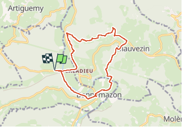

Length
8.4 km

Max alt
539 m

Uphill gradient
307 m
Km-Effort
12.5 km

Min alt
309 m

Downhill gradient
308 m
Boucle
Yes
Creation date :
2024-06-22 09:04:02.621
Updated on :
2024-06-22 13:37:43.509
4h32
Difficulty : Difficult

FREE GPS app for hiking
 SityTrail
IGN / Geographical institutes
SityTrail Plus
The world is yours!
About
Trail Walking of 8.4 km to be discovered at Occitania, Hautespyrenees, Bonnemazon. This trail is proposed by Childebert.
Photos

Positioning
Country:
France
Region :
Occitania
Department/Province :
Hautespyrenees
Municipality :
Bonnemazon
Location:
Unknown
Start:(Dec)
Start:(UTM)
276706 ; 4776676 (31T) N.
Comments