


circuit uit d'équipe vendangeoirs

alainwald
User
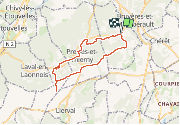

Length
13.2 km

Max alt
180 m

Uphill gradient
212 m
Km-Effort
16 km

Min alt
76 m

Downhill gradient
212 m
Boucle
Yes
Creation date :
2024-06-09 13:55:13.752
Updated on :
2024-06-22 17:21:14.286
3h49
Difficulty : Medium

FREE GPS app for hiking
 SityTrail
IGN / Geographical institutes
SityTrail Plus
The world is yours!
About
Trail Walking of 13.2 km to be discovered at Hauts-de-France, Aisne, Vorges. This trail is proposed by alainwald.
Description
entre beaux villages, plaines et forets
Photos


Positioning
Country:
France
Region :
Hauts-de-France
Department/Province :
Aisne
Municipality :
Vorges
Location:
Unknown
Start:(Dec)
Start:(UTM)
547427 ; 5485230 (31U) N.
Comments