


Rieutord Ardeche

tyntyn
User
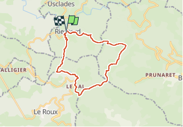

Length
14 km

Max alt
1320 m

Uphill gradient
372 m
Km-Effort
19 km

Min alt
1123 m

Downhill gradient
371 m
Boucle
Yes
Creation date :
2024-06-23 07:47:26.26
Updated on :
2024-06-23 13:08:47.751
4h49
Difficulty : Easy

FREE GPS app for hiking
 SityTrail
IGN / Geographical institutes
SityTrail Plus
The world is yours!
About
Trail Walking of 14 km to be discovered at Auvergne-Rhône-Alpes, Ardèche, Usclades-et-Rieutord. This trail is proposed by tyntyn.
Positioning
Country:
France
Region :
Auvergne-Rhône-Alpes
Department/Province :
Ardèche
Municipality :
Usclades-et-Rieutord
Location:
Unknown
Start:(Dec)
Start:(UTM)
591957 ; 4957193 (31T) N.
Comments