


Tour de Serris Baudéan

chasle
User
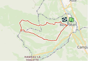

Length
7.9 km

Max alt
962 m

Uphill gradient
347 m
Km-Effort
12.5 km

Min alt
635 m

Downhill gradient
347 m
Boucle
Yes
Creation date :
2024-06-23 08:38:40.113
Updated on :
2024-06-23 15:46:37.973
2h50
Difficulty : Medium

FREE GPS app for hiking
 SityTrail
IGN / Geographical institutes
SityTrail Plus
The world is yours!
About
Trail Walking of 7.9 km to be discovered at Occitania, Hautespyrenees, Beaudéan. This trail is proposed by chasle.
Positioning
Country:
France
Region :
Occitania
Department/Province :
Hautespyrenees
Municipality :
Beaudéan
Location:
Unknown
Start:(Dec)
Start:(UTM)
269104 ; 4767892 (31T) N.
Comments