


st rome de cernon lapanouse

lablaquiere
User
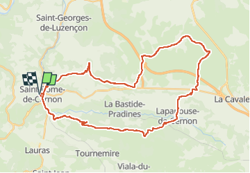

Length
44 km

Max alt
859 m

Uphill gradient
1125 m
Km-Effort
59 km

Min alt
398 m

Downhill gradient
1123 m
Boucle
Yes
Creation date :
2024-06-23 13:05:52.7
Updated on :
2024-06-23 17:16:02.382
3h22
Difficulty : Very difficult

FREE GPS app for hiking
 SityTrail
IGN / Geographical institutes
SityTrail Plus
The world is yours!
About
Trail Mountain bike of 44 km to be discovered at Occitania, Aveyron, Saint-Rome-de-Cernon. This trail is proposed by lablaquiere.
Positioning
Country:
France
Region :
Occitania
Department/Province :
Aveyron
Municipality :
Saint-Rome-de-Cernon
Location:
Unknown
Start:(Dec)
Start:(UTM)
496970 ; 4873170 (31T) N.
Comments