


Mézilhac Cham de Mars

pb07
User
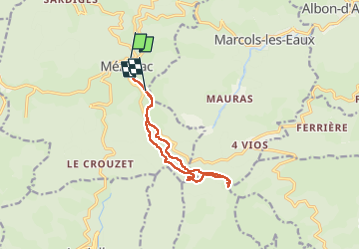

Length
12 km

Max alt
1337 m

Uphill gradient
343 m
Km-Effort
16.5 km

Min alt
1142 m

Downhill gradient
313 m
Boucle
No
Creation date :
2024-06-24 07:57:29.685
Updated on :
2024-06-24 14:00:04.946
3h50
Difficulty : Difficult

FREE GPS app for hiking
 SityTrail
IGN / Geographical institutes
SityTrail Plus
The world is yours!
About
Trail Walking of 12 km to be discovered at Auvergne-Rhône-Alpes, Ardèche, Mézilhac. This trail is proposed by pb07.
Positioning
Country:
France
Region :
Auvergne-Rhône-Alpes
Department/Province :
Ardèche
Municipality :
Mézilhac
Location:
Unknown
Start:(Dec)
Start:(UTM)
606919 ; 4962514 (31T) N.
Comments