


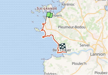
2024 RA J4 Bretagne costamoricaine

dfluzin
User

Length
13.3 km

Max alt
67 m

Uphill gradient
335 m
Km-Effort
17.6 km

Min alt
0 m

Downhill gradient
292 m
Boucle
No
Creation date :
2024-06-24 08:22:38.4
Updated on :
2024-06-24 14:33:02.077
3h21
Difficulty : Medium

FREE GPS app for hiking
 SityTrail
IGN / Geographical institutes
SityTrail Plus
The world is yours!
About
Trail Walking of 13.3 km to be discovered at Brittany, Côtes-d'Armor, Trébeurden. This trail is proposed by dfluzin.
Photos


36 photos in total. Please click on a photo to see them all in the gallery.
Positioning
Country:
France
Region :
Brittany
Department/Province :
Côtes-d'Armor
Municipality :
Trébeurden
Location:
Unknown
Start:(Dec)
Start:(UTM)
457493 ; 5403314 (30U) N.
Comments