


Bagnères Luchon St Lary etap1 espagon

taguette
User
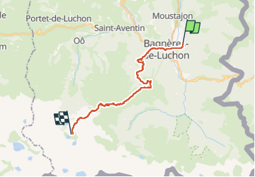

Length
22 km

Max alt
2273 m

Uphill gradient
2061 m
Km-Effort
45 km

Min alt
625 m

Downhill gradient
736 m
Boucle
No
Creation date :
2024-06-23 06:16:28.001
Updated on :
2024-06-24 15:50:18.869
10h40
Difficulty : Very difficult

FREE GPS app for hiking
 SityTrail
IGN / Geographical institutes
SityTrail Plus
The world is yours!
About
Trail Walking of 22 km to be discovered at Occitania, Haute-Garonne, Montauban-de-Luchon. This trail is proposed by taguette.
Positioning
Country:
France
Region :
Occitania
Department/Province :
Haute-Garonne
Municipality :
Montauban-de-Luchon
Location:
Unknown
Start:(Dec)
Start:(UTM)
304345 ; 4740876 (31T) N.
Comments