


Bagnères de Luchon St Lary etap2 Loudanvieille

taguette
User
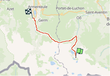

Length
20 km

Max alt
2137 m

Uphill gradient
1072 m
Km-Effort
38 km

Min alt
962 m

Downhill gradient
2043 m
Boucle
No
Creation date :
2024-06-24 06:03:27.447
Updated on :
2024-06-24 17:12:28.924
9h29
Difficulty : Very difficult

FREE GPS app for hiking
 SityTrail
IGN / Geographical institutes
SityTrail Plus
The world is yours!
About
Trail Walking of 20 km to be discovered at Occitania, Haute-Garonne, Oô. This trail is proposed by taguette.
Positioning
Country:
France
Region :
Occitania
Department/Province :
Haute-Garonne
Municipality :
Oô
Location:
Unknown
Start:(Dec)
Start:(UTM)
295309 ; 4733937 (31T) N.
Comments