


Lacs Adiden

chasle
User
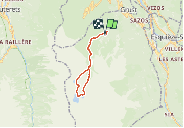

Length
12.4 km

Max alt
2455 m

Uphill gradient
1064 m
Km-Effort
27 km

Min alt
1391 m

Downhill gradient
1069 m
Boucle
Yes
Creation date :
2024-06-25 05:08:02.901
Updated on :
2024-06-25 16:31:31.679
4h37
Difficulty : Difficult

FREE GPS app for hiking
 SityTrail
IGN / Geographical institutes
SityTrail Plus
The world is yours!
About
Trail Walking of 12.4 km to be discovered at Occitania, Hautespyrenees, Sazos. This trail is proposed by chasle.
Positioning
Country:
France
Region :
Occitania
Department/Province :
Hautespyrenees
Municipality :
Sazos
Location:
Unknown
Start:(Dec)
Start:(UTM)
741136 ; 4751315 (30T) N.
Comments