


lp80_Onival-BoisCise 8km

GR77LP
User
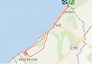

Length
7.8 km

Max alt
82 m

Uphill gradient
172 m
Km-Effort
10.1 km

Min alt
0 m

Downhill gradient
173 m
Boucle
Yes
Creation date :
2024-06-25 15:16:06.429
Updated on :
2024-06-25 15:16:09.042
2h17
Difficulty : Medium

FREE GPS app for hiking
 SityTrail
IGN / Geographical institutes
SityTrail Plus
The world is yours!
About
Trail Walking of 7.8 km to be discovered at Hauts-de-France, Somme, Ault. This trail is proposed by GR77LP.
Positioning
Country:
France
Region :
Hauts-de-France
Department/Province :
Somme
Municipality :
Ault
Location:
Unknown
Start:(Dec)
Start:(UTM)
389483 ; 5551901 (31U) N.
Comments