


Bagnères de Luchon St Lary de soulan etap3

taguette
User
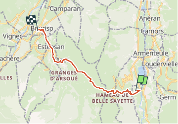

Length
11.3 km

Max alt
1583 m

Uphill gradient
617 m
Km-Effort
20 km

Min alt
799 m

Downhill gradient
800 m
Boucle
No
Creation date :
2024-06-25 07:10:46.369
Updated on :
2024-06-26 13:39:10.834
6h01
Difficulty : Very difficult

FREE GPS app for hiking
 SityTrail
IGN / Geographical institutes
SityTrail Plus
The world is yours!
About
Trail Walking of 11.3 km to be discovered at Occitania, Hautespyrenees, Loudenvielle. This trail is proposed by taguette.
Positioning
Country:
France
Region :
Occitania
Department/Province :
Hautespyrenees
Municipality :
Loudenvielle
Location:
Loudenvielle
Start:(Dec)
Start:(UTM)
287670 ; 4741453 (31T) N.
Comments