


étang de Lers

bouscaillou
User
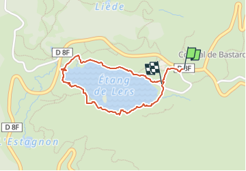

Length
1.7 km

Max alt
1305 m

Uphill gradient
18 m
Km-Effort
2.1 km

Min alt
1271 m

Downhill gradient
40 m
Boucle
Yes
Creation date :
2024-06-26 12:44:37.875
Updated on :
2024-06-26 13:47:21.658
1h01
Difficulty : Easy

FREE GPS app for hiking
 SityTrail
IGN / Geographical institutes
SityTrail Plus
The world is yours!
About
Trail Walking of 1.7 km to be discovered at Occitania, Ariège, Le Port. This trail is proposed by bouscaillou.
Positioning
Country:
France
Region :
Occitania
Department/Province :
Ariège
Municipality :
Le Port
Location:
Unknown
Start:(Dec)
Start:(UTM)
367718 ; 4740789 (31T) N.
Comments