


20240621 leves

Jeanclaudebic
User
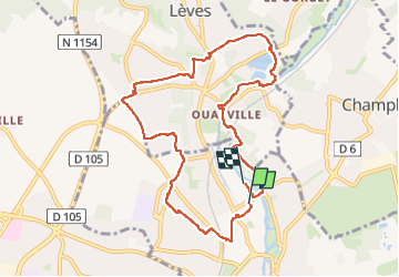

Length
9.1 km

Max alt
156 m

Uphill gradient
123 m
Km-Effort
10.7 km

Min alt
119 m

Downhill gradient
125 m
Boucle
No
Creation date :
2024-06-21 12:05:42.521
Updated on :
2024-06-27 12:59:28.103
2h23
Difficulty : Medium

FREE GPS app for hiking
 SityTrail
IGN / Geographical institutes
SityTrail Plus
The world is yours!
About
Trail Walking of 9.1 km to be discovered at Centre-Loire Valley, Eure-et-Loir, Chartres. This trail is proposed by Jeanclaudebic.
Positioning
Country:
France
Region :
Centre-Loire Valley
Department/Province :
Eure-et-Loir
Municipality :
Chartres
Location:
Unknown
Start:(Dec)
Start:(UTM)
388201 ; 5368355 (31U) N.
Comments