


lac de champey

suzanne.bron
User
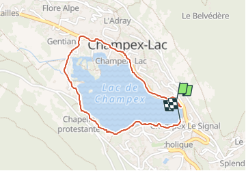

Length
1.7 km

Max alt
1481 m

Uphill gradient
21 m
Km-Effort
2 km

Min alt
1469 m

Downhill gradient
16 m
Boucle
Yes
Creation date :
2024-06-28 07:36:56.018
Updated on :
2024-06-28 08:14:54.645
37m
Difficulty : Easy

FREE GPS app for hiking
 SityTrail
IGN / Geographical institutes
SityTrail Plus
The world is yours!
About
Trail Walking of 1.7 km to be discovered at Valais/Wallis, Entremont, Orsières. This trail is proposed by suzanne.bron.
Positioning
Country:
Switzerland
Region :
Valais/Wallis
Department/Province :
Entremont
Municipality :
Orsières
Location:
Unknown
Start:(Dec)
Start:(UTM)
354491 ; 5098870 (32T) N.
Comments