


Vercors Col Vert

c.gourme
User
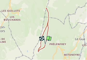

Length
11.7 km

Max alt
1750 m

Uphill gradient
573 m
Km-Effort
19.4 km

Min alt
1284 m

Downhill gradient
577 m
Boucle
Yes
Creation date :
2024-06-29 06:26:46.0
Updated on :
2024-06-29 12:29:03.577

FREE GPS app for hiking
 SityTrail
IGN / Geographical institutes
SityTrail Plus
The world is yours!
About
Trail of 11.7 km to be discovered at Auvergne-Rhône-Alpes, Isère, Le Gua. This trail is proposed by c.gourme.
Positioning
Country:
France
Region :
Auvergne-Rhône-Alpes
Department/Province :
Isère
Municipality :
Le Gua
Location:
Unknown
Start:(Dec)
Start:(UTM)
704542 ; 4988098 (31T) N.
Comments