


Vars J1 20240630

cmike39
User
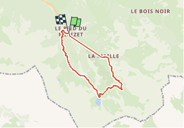

Length
13.5 km

Max alt
2413 m

Uphill gradient
810 m
Km-Effort
24 km

Min alt
1680 m

Downhill gradient
825 m
Boucle
Yes
Creation date :
2024-06-30 07:41:57.25
Updated on :
2024-06-30 14:22:36.07
3h30
Difficulty : Very difficult

FREE GPS app for hiking
 SityTrail
IGN / Geographical institutes
SityTrail Plus
The world is yours!
About
Trail Walking of 13.5 km to be discovered at Provence-Alpes-Côte d'Azur, Hautes-Alpes, Ceillac. This trail is proposed by cmike39.
Positioning
Country:
France
Region :
Provence-Alpes-Côte d'Azur
Department/Province :
Hautes-Alpes
Municipality :
Ceillac
Location:
Unknown
Start:(Dec)
Start:(UTM)
324874 ; 4946389 (32T) N.
Comments