


journée 2

berlage
User
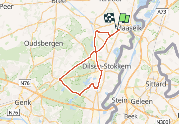

Length
46 km

Max alt
98 m

Uphill gradient
320 m
Km-Effort
50 km

Min alt
25 m

Downhill gradient
320 m
Boucle
No
Creation date :
2024-06-30 10:05:42.26
Updated on :
2024-06-30 15:29:47.299
5h21
Difficulty : Medium

FREE GPS app for hiking
 SityTrail
IGN / Geographical institutes
SityTrail Plus
The world is yours!
About
Trail Walking of 46 km to be discovered at Flanders, Limburg, Maaseik. This trail is proposed by berlage.
Positioning
Country:
Belgium
Region :
Flanders
Department/Province :
Limburg
Municipality :
Maaseik
Location:
Maaseik
Start:(Dec)
Start:(UTM)
693387 ; 5663666 (31U) N.
Comments