


Les etangs de Chaleires

meillon
User

Length
7.1 km

Max alt
200 m

Uphill gradient
35 m
Km-Effort
7.5 km

Min alt
174 m

Downhill gradient
35 m
Boucle
Yes
Creation date :
2024-06-30 13:29:37.611
Updated on :
2024-06-30 15:36:55.793
2h06
Difficulty : Easy

FREE GPS app for hiking
 SityTrail
IGN / Geographical institutes
SityTrail Plus
The world is yours!
About
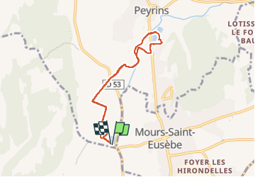
Trail Walking of 7.1 km to be discovered at Auvergne-Rhône-Alpes, Drôme, Peyrins. This trail is proposed by meillon.
Description
passage par les derivations jusqu aux etangs de belle vue a Peyrins
Positioning
Country:
France
Region :
Auvergne-Rhône-Alpes
Department/Province :
Drôme
Municipality :
Peyrins
Location:
Unknown
Start:(Dec)
Start:(UTM)
660459 ; 4992663 (31T) N.
Comments