


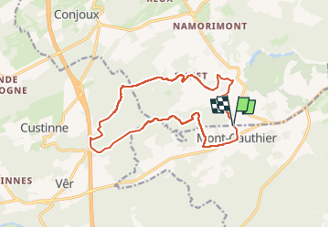
Montgauthier

BrigitteBertrand
User

Length
13.8 km

Max alt
309 m

Uphill gradient
266 m
Km-Effort
17.3 km

Min alt
199 m

Downhill gradient
264 m
Boucle
Yes
Creation date :
2024-06-30 11:19:19.0
Updated on :
2024-07-01 17:09:21.839
3h55
Difficulty : Difficult

FREE GPS app for hiking
 SityTrail
IGN / Geographical institutes
SityTrail Plus
The world is yours!
About
Trail Walking of 13.8 km to be discovered at Wallonia, Namur, Rochefort. This trail is proposed by BrigitteBertrand.
Description
Vers Chevetogne, du haut ...Enhet, puis la tombe du loup.. du bas en longeant l'Ywoigne. Remontée ensuite vers le village et la rue des Grêlons
Photos


Positioning
Country:
Belgium
Region :
Wallonia
Department/Province :
Namur
Municipality :
Rochefort
Location:
Unknown
Start:(Dec)
Start:(UTM)
651231 ; 5564380 (31U) N.
Comments