


veigy_feternes-3711969-1719765424-568

topolino
User
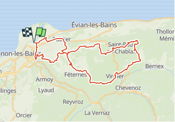

Length
41 km

Max alt
976 m

Uphill gradient
881 m
Km-Effort
53 km

Min alt
387 m

Downhill gradient
880 m
Boucle
Yes
Creation date :
2024-06-30 16:38:25.082
Updated on :
2024-06-30 16:39:12.03
3h39
Difficulty : Very difficult

FREE GPS app for hiking
 SityTrail
IGN / Geographical institutes
SityTrail Plus
The world is yours!
About
Trail Mountain bike of 41 km to be discovered at Auvergne-Rhône-Alpes, Upper Savoy, Thonon-les-Bains. This trail is proposed by topolino.
Positioning
Country:
France
Region :
Auvergne-Rhône-Alpes
Department/Province :
Upper Savoy
Municipality :
Thonon-les-Bains
Location:
Unknown
Start:(Dec)
Start:(UTM)
308167 ; 5139614 (32T) N.
Comments