


Cucuron Vaugines

counoise
User
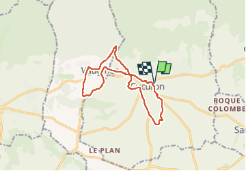

Length
13.8 km

Max alt
451 m

Uphill gradient
269 m
Km-Effort
17.4 km

Min alt
289 m

Downhill gradient
269 m
Boucle
Yes
Creation date :
2024-06-23 13:48:51.632
Updated on :
2024-06-30 18:02:04.804
2h53
Difficulty : Easy

FREE GPS app for hiking
 SityTrail
IGN / Geographical institutes
SityTrail Plus
The world is yours!
About
Trail Walking of 13.8 km to be discovered at Provence-Alpes-Côte d'Azur, Vaucluse, Cucuron. This trail is proposed by counoise.
Photos


Positioning
Country:
France
Region :
Provence-Alpes-Côte d'Azur
Department/Province :
Vaucluse
Municipality :
Cucuron
Location:
Unknown
Start:(Dec)
Start:(UTM)
696575 ; 4849660 (31T) N.
Comments