


Cassagnas > st Germain de Calberte

catduv
User
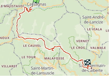

Length
17.4 km

Max alt
1032 m

Uphill gradient
428 m
Km-Effort
24 km

Min alt
492 m

Downhill gradient
712 m
Boucle
No
Creation date :
2024-07-02 06:47:36.03
Updated on :
2024-07-02 14:38:04.864
5h05
Difficulty : Easy

FREE GPS app for hiking
 SityTrail
IGN / Geographical institutes
SityTrail Plus
The world is yours!
About
Trail Walking of 17.4 km to be discovered at Occitania, Lozère, Cassagnas. This trail is proposed by catduv.
Positioning
Country:
France
Region :
Occitania
Department/Province :
Lozère
Municipality :
Cassagnas
Location:
Unknown
Start:(Dec)
Start:(UTM)
559172 ; 4901942 (31T) N.
Comments