


Granon - Peyrolle

cron
User
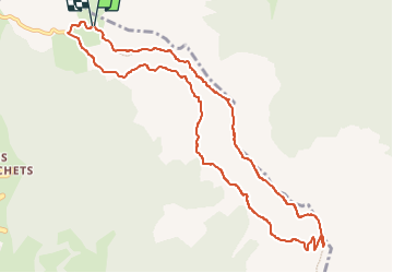

Length
11 km

Max alt
2611 m

Uphill gradient
485 m
Km-Effort
17.5 km

Min alt
2306 m

Downhill gradient
488 m
Boucle
Yes
Creation date :
2024-07-03 14:26:05.032
Updated on :
2024-07-07 14:34:16.526
3h58
Difficulty : Medium

FREE GPS app for hiking
 SityTrail
IGN / Geographical institutes
SityTrail Plus
The world is yours!
About
Trail Walking of 11 km to be discovered at Provence-Alpes-Côte d'Azur, Hautes-Alpes, Saint-Chaffrey. This trail is proposed by cron.
Description
Cette randonnée, sans être aérienne, présente quelques passages qui peuvent déplaire aux personnes sujettes au vertige ...
Positioning
Country:
France
Region :
Provence-Alpes-Côte d'Azur
Department/Province :
Hautes-Alpes
Municipality :
Saint-Chaffrey
Location:
Unknown
Start:(Dec)
Start:(UTM)
311590 ; 4981587 (32T) N.
Comments