


Mercantour J6

becor94
User
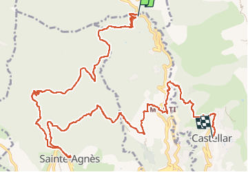

Length
16.2 km

Max alt
721 m

Uphill gradient
687 m
Km-Effort
25 km

Min alt
163 m

Downhill gradient
716 m
Boucle
No
Creation date :
2024-07-03 06:17:48.0
Updated on :
2024-07-03 14:42:11.675
6h14
Difficulty : Very difficult

FREE GPS app for hiking
 SityTrail
IGN / Geographical institutes
SityTrail Plus
The world is yours!
About
Trail Walking of 16.2 km to be discovered at Provence-Alpes-Côte d'Azur, Maritime Alps, Menton. This trail is proposed by becor94.
Description
Par st agnes et castellar
Positioning
Country:
France
Region :
Provence-Alpes-Côte d'Azur
Department/Province :
Maritime Alps
Municipality :
Menton
Location:
Unknown
Start:(Dec)
Start:(UTM)
377656 ; 4853692 (32T) N.
Comments