


st Germain de Calberte > st Jean du Gard

catduv
User
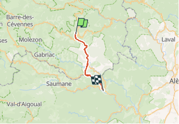

Length
23 km

Max alt
677 m

Uphill gradient
807 m
Km-Effort
35 km

Min alt
194 m

Downhill gradient
1108 m
Boucle
No
Creation date :
2024-07-03 06:22:33.129
Updated on :
2024-07-03 16:21:05.419
6h54
Difficulty : Medium

FREE GPS app for hiking
 SityTrail
IGN / Geographical institutes
SityTrail Plus
The world is yours!
About
Trail Walking of 23 km to be discovered at Occitania, Lozère, Saint-Germain-de-Calberte. This trail is proposed by catduv.
Positioning
Country:
France
Region :
Occitania
Department/Province :
Lozère
Municipality :
Saint-Germain-de-Calberte
Location:
Unknown
Start:(Dec)
Start:(UTM)
564600 ; 4896395 (31T) N.
Comments