


Muret Bétance Estantens

pidjam
User
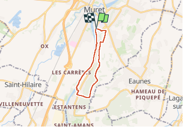

Length
9.8 km

Max alt
288 m

Uphill gradient
186 m
Km-Effort
12.3 km

Min alt
160 m

Downhill gradient
186 m
Boucle
Yes
Creation date :
2024-07-04 06:51:34.965
Updated on :
2024-07-04 09:41:59.714
2h23
Difficulty : Easy

FREE GPS app for hiking
 SityTrail
IGN / Geographical institutes
SityTrail Plus
The world is yours!
About
Trail Walking of 9.8 km to be discovered at Occitania, Haute-Garonne, Muret. This trail is proposed by pidjam.
Positioning
Country:
France
Region :
Occitania
Department/Province :
Haute-Garonne
Municipality :
Muret
Location:
Unknown
Start:(Dec)
Start:(UTM)
364699 ; 4812168 (31T) N.
Comments