


Lannaken1

castorgris
User
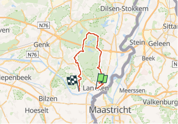

Length
32 km

Max alt
112 m

Uphill gradient
241 m
Km-Effort
35 km

Min alt
44 m

Downhill gradient
215 m
Boucle
No
Creation date :
2024-07-04 07:55:31.0
Updated on :
2024-07-04 10:38:25.15

FREE GPS app for hiking
 SityTrail
IGN / Geographical institutes
SityTrail Plus
The world is yours!
About
Trail of 32 km to be discovered at Flanders, Limburg, Lanaken. This trail is proposed by castorgris.
Description
Facile
Positioning
Country:
Belgium
Region :
Flanders
Department/Province :
Limburg
Municipality :
Lanaken
Location:
Lanaken
Start:(Dec)
Start:(UTM)
686518 ; 5640543 (31U) N.
Comments