


charroux

kronio
User
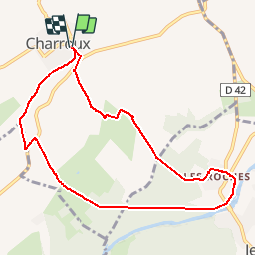

Length
9.1 km

Max alt
418 m

Uphill gradient
291 m
Km-Effort
13 km

Min alt
278 m

Downhill gradient
290 m
Boucle
Yes
Creation date :
2015-04-22 00:00:00.0
Updated on :
2015-04-22 00:00:00.0
3h21
Difficulty : Easy

FREE GPS app for hiking
 SityTrail
IGN / Geographical institutes
SityTrail Plus
The world is yours!
About
Trail Other activity of 9.1 km to be discovered at Auvergne-Rhône-Alpes, Allier, Charroux. This trail is proposed by kronio.
Description
Charroux au tour de la Sioulle
Positioning
Country:
France
Region :
Auvergne-Rhône-Alpes
Department/Province :
Allier
Municipality :
Charroux
Location:
Unknown
Start:(Dec)
Start:(UTM)
512567 ; 5114519 (31T) N.
Comments