


Runmeter-Run-20150419-0922.gpx

kronio
User
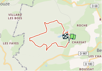

Length
6.9 km

Max alt
530 m

Uphill gradient
144 m
Km-Effort
8.8 km

Min alt
419 m

Downhill gradient
143 m
Boucle
Yes
Creation date :
2015-04-22 00:00:00.0
Updated on :
2015-04-22 00:00:00.0
--
Difficulty : Unknown

FREE GPS app for hiking
 SityTrail
IGN / Geographical institutes
SityTrail Plus
The world is yours!
About
Trail Other activity of 6.9 km to be discovered at Auvergne-Rhône-Alpes, Allier, Bellenaves. This trail is proposed by kronio.
Description
Runmeter Course 19 avr. 2015 09:22:19
Positioning
Country:
France
Region :
Auvergne-Rhône-Alpes
Department/Province :
Allier
Municipality :
Bellenaves
Location:
Unknown
Start:(Dec)
Start:(UTM)
504235 ; 5116522 (31T) N.
Comments