


J4 Annot

ETMU5496
User
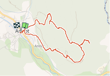

Length
6.2 km

Max alt
1040 m

Uphill gradient
382 m
Km-Effort
11.3 km

Min alt
689 m

Downhill gradient
382 m
Boucle
Yes
Creation date :
2024-07-04 08:29:56.0
Updated on :
2024-07-31 14:03:46.77
2h34
Difficulty : Medium

FREE GPS app for hiking
 SityTrail
IGN / Geographical institutes
SityTrail Plus
The world is yours!
About
Trail Walking of 6.2 km to be discovered at Provence-Alpes-Côte d'Azur, Alpes-de-Haute-Provence, Annot. This trail is proposed by ETMU5496.
Description
Grès d’Annot
IBP=52
Photos


42 photos in total. Please click on a photo to see them all in the gallery.
Positioning
Country:
France
Region :
Provence-Alpes-Côte d'Azur
Department/Province :
Alpes-de-Haute-Provence
Municipality :
Annot
Location:
Unknown
Start:(Dec)
Start:(UTM)
312859 ; 4870718 (32T) N.
Comments