


Binic la Banche - GR34 Plage des Rosaires - 22.2km 530m 5h10 (35mn) - 2024 07 04

Orcal37
User GUIDE
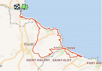

Length
22 km

Max alt
111 m

Uphill gradient
529 m
Km-Effort
29 km

Min alt
0 m

Downhill gradient
529 m
Boucle
Yes
Creation date :
2024-07-04 09:25:40.277
Updated on :
2024-08-10 10:25:31.486
5h10
Difficulty : Difficult

FREE GPS app for hiking
 SityTrail
IGN / Geographical institutes
SityTrail Plus
The world is yours!
About
Trail Walking of 22 km to be discovered at Brittany, Côtes-d'Armor, Binic-Étables-sur-Mer. This trail is proposed by Orcal37.
Description
Binic Plage de la Banche - GR34 - Plage des Rosaires de Plérin - 22.2km 530m 5h10 (35mn) - 2024 07 04
Photos
 - 2024 07 04 - Photo 1")
 - 2024 07 04 - Photo 2")
 - 2024 07 04 - Photo 3")
 - 2024 07 04 - Photo 4")
 - 2024 07 04 - Photo 5")
 - 2024 07 04 - Photo 6")
 - 2024 07 04 - Photo 7")
 - 2024 07 04 - Photo 8")
 - 2024 07 04 - Photo 9")
 - 2024 07 04 - Photo 10")
 - 2024 07 04 - Photo 11")
 - 2024 07 04 - Photo 12")
 - 2024 07 04 - Photo 13")
 - 2024 07 04 - Photo 14")
 - 2024 07 04 - Photo 15")
Positioning
Country:
France
Region :
Brittany
Department/Province :
Côtes-d'Armor
Municipality :
Binic-Étables-sur-Mer
Location:
Binic
Start:(Dec)
Start:(UTM)
512950 ; 5382684 (30U) N.
Comments
