


20240628 wx xxcc

Jeanclaudebic
User
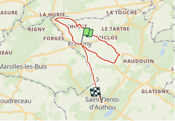

Length
13.4 km

Max alt
244 m

Uphill gradient
140 m
Km-Effort
15.2 km

Min alt
164 m

Downhill gradient
128 m
Boucle
No
Creation date :
2024-06-28 06:51:17.095
Updated on :
2024-07-05 08:12:55.226
5h43
Difficulty : Difficult

FREE GPS app for hiking
 SityTrail
IGN / Geographical institutes
SityTrail Plus
The world is yours!
About
Trail Walking of 13.4 km to be discovered at Centre-Loire Valley, Eure-et-Loir, Saintigny. This trail is proposed by Jeanclaudebic.
Positioning
Country:
France
Region :
Centre-Loire Valley
Department/Province :
Eure-et-Loir
Municipality :
Saintigny
Location:
Unknown
Start:(Dec)
Start:(UTM)
349651 ; 5359782 (31U) N.
Comments