


20240630 Thiron Garder

Jeanclaudebic
User

Length
11.6 km

Max alt
280 m

Uphill gradient
149 m
Km-Effort
13.5 km

Min alt
230 m

Downhill gradient
148 m
Boucle
Yes
Creation date :
2024-06-30 06:43:01.958
Updated on :
2024-07-05 08:12:56.64
2h58
Difficulty : Difficult

FREE GPS app for hiking
 SityTrail
IGN / Geographical institutes
SityTrail Plus
The world is yours!
About
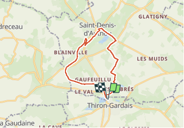
Trail Walking of 11.6 km to be discovered at Centre-Loire Valley, Eure-et-Loir, Thiron-Gardais. This trail is proposed by Jeanclaudebic.
Positioning
Country:
France
Region :
Centre-Loire Valley
Department/Province :
Eure-et-Loir
Municipality :
Thiron-Gardais
Location:
Unknown
Start:(Dec)
Start:(UTM)
351103 ; 5353122 (31U) N.
Comments