


baraques to chapelle en Vercors

fdm1
User
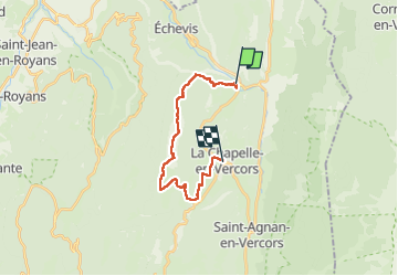

Length
16.9 km

Max alt
1168 m

Uphill gradient
688 m
Km-Effort
25 km

Min alt
681 m

Downhill gradient
489 m
Boucle
No
Creation date :
2024-07-05 07:19:38.292
Updated on :
2024-07-05 12:42:45.489
5h22
Difficulty : Medium

FREE GPS app for hiking
 SityTrail
IGN / Geographical institutes
SityTrail Plus
The world is yours!
About
Trail Walking of 16.9 km to be discovered at Auvergne-Rhône-Alpes, Drôme, Saint-Martin-en-Vercors. This trail is proposed by fdm1.
Description
Découverte nature
Positioning
Country:
France
Region :
Auvergne-Rhône-Alpes
Department/Province :
Drôme
Municipality :
Saint-Martin-en-Vercors
Location:
Unknown
Start:(Dec)
Start:(UTM)
690890 ; 4986032 (31T) N.
Comments