


2024 RA Cantal Puy Mary

dfluzin
User
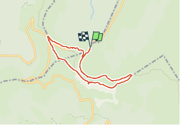

Length
7.8 km

Max alt
1769 m

Uphill gradient
443 m
Km-Effort
13.7 km

Min alt
1421 m

Downhill gradient
443 m
Boucle
Yes
Creation date :
2024-07-05 07:52:07.983
Updated on :
2024-07-05 13:56:23.827
2h50
Difficulty : Difficult

FREE GPS app for hiking
 SityTrail
IGN / Geographical institutes
SityTrail Plus
The world is yours!
About
Trail Walking of 7.8 km to be discovered at Auvergne-Rhône-Alpes, Cantal, Lavigerie. This trail is proposed by dfluzin.
Photos


36 photos in total. Please click on a photo to see them all in the gallery.
Positioning
Country:
France
Region :
Auvergne-Rhône-Alpes
Department/Province :
Cantal
Municipality :
Lavigerie
Location:
Unknown
Start:(Dec)
Start:(UTM)
475319 ; 4995463 (31T) N.
Comments