


Le tour du Mont Mézenc en Ardèche

ilur56
User
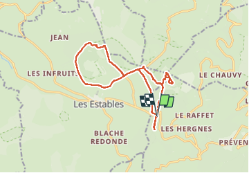

Length
16.4 km

Max alt
1740 m

Uphill gradient
512 m
Km-Effort
23 km

Min alt
1421 m

Downhill gradient
512 m
Boucle
Yes
Creation date :
2024-07-05 07:50:53.743
Updated on :
2024-07-11 19:15:55.711
4h21
Difficulty : Medium

FREE GPS app for hiking
 SityTrail
IGN / Geographical institutes
SityTrail Plus
The world is yours!
About
Trail Walking of 16.4 km to be discovered at Auvergne-Rhône-Alpes, Ardèche, Borée. This trail is proposed by ilur56.
Description
Tour du Mont Mézenc au départ du col des Boutières et tour du Mont Alambre;
Photos


Positioning
Country:
France
Region :
Auvergne-Rhône-Alpes
Department/Province :
Ardèche
Municipality :
Borée
Location:
Unknown
Start:(Dec)
Start:(UTM)
593567 ; 4972408 (31T) N.
Comments