


Mende /La Bruyère / La Colombeche

tyntyn
User
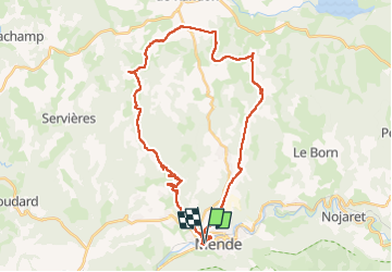

Length
37 km

Max alt
1295 m

Uphill gradient
915 m
Km-Effort
49 km

Min alt
710 m

Downhill gradient
916 m
Boucle
Yes
Creation date :
2024-07-05 11:26:21.212
Updated on :
2024-07-05 15:13:18.11
3h46
Difficulty : Easy

FREE GPS app for hiking
 SityTrail
IGN / Geographical institutes
SityTrail Plus
The world is yours!
About
Trail Mountain bike of 37 km to be discovered at Occitania, Lozère, Mende. This trail is proposed by tyntyn.
Positioning
Country:
France
Region :
Occitania
Department/Province :
Lozère
Municipality :
Mende
Location:
Unknown
Start:(Dec)
Start:(UTM)
538998 ; 4929611 (31T) N.
Comments