


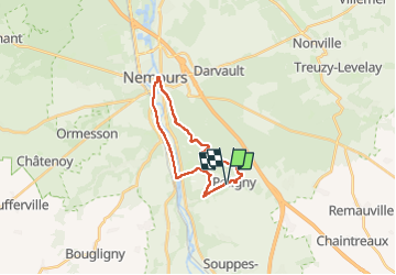
de poligny à nemours/ A/R

Isidore Hernandez 2
User

Length
18.4 km

Max alt
128 m

Uphill gradient
200 m
Km-Effort
21 km

Min alt
57 m

Downhill gradient
201 m
Boucle
Yes
Creation date :
2024-07-06 06:43:16.18
Updated on :
2024-07-06 09:48:19.334
3h03
Difficulty : Easy

FREE GPS app for hiking
 SityTrail
IGN / Geographical institutes
SityTrail Plus
The world is yours!
About
Trail Nordic walking of 18.4 km to be discovered at Ile-de-France, Seine-et-Marne, Poligny. This trail is proposed by Isidore Hernandez 2.
Positioning
Country:
France
Region :
Ile-de-France
Department/Province :
Seine-et-Marne
Municipality :
Poligny
Location:
Unknown
Start:(Dec)
Start:(UTM)
480745 ; 5341153 (31U) N.
Comments