


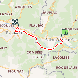
Saint Côme - Espalion

RR31
User

Length
7.1 km

Max alt
387 m

Uphill gradient
77 m
Km-Effort
8.3 km

Min alt
334 m

Downhill gradient
112 m
Boucle
No
Creation date :
2015-04-23 00:00:00.0
Updated on :
2015-04-23 00:00:00.0
2h10
Difficulty : Medium

FREE GPS app for hiking
 SityTrail
IGN / Geographical institutes
SityTrail Plus
The world is yours!
About
Trail Walking of 7.1 km to be discovered at Occitania, Aveyron, Saint-Côme-d'Olt. This trail is proposed by RR31.
Description
Saint Jacques
Photos


Positioning
Country:
France
Region :
Occitania
Department/Province :
Aveyron
Municipality :
Saint-Côme-d'Olt
Location:
Unknown
Start:(Dec)
Start:(UTM)
485253 ; 4929154 (31T) N.
Comments