


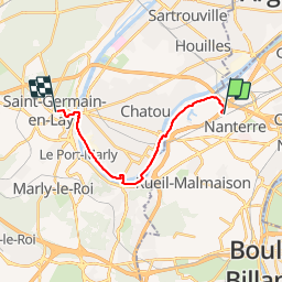
nanterre st germain

olivieraron
User

Length
13.9 km

Max alt
91 m

Uphill gradient
169 m
Km-Effort
16 km

Min alt
17 m

Downhill gradient
109 m
Boucle
No
Creation date :
2019-01-14 09:45:55.864
Updated on :
2019-01-14 09:45:55.936
3h20
Difficulty : Unknown

FREE GPS app for hiking
 SityTrail
IGN / Geographical institutes
SityTrail Plus
The world is yours!
About
Trail Other activity of 13.9 km to be discovered at Ile-de-France, Hauts-de-Seine, Nanterre. This trail is proposed by olivieraron.
Positioning
Country:
France
Region :
Ile-de-France
Department/Province :
Hauts-de-Seine
Municipality :
Nanterre
Location:
Unknown
Start:(Dec)
Start:(UTM)
441358 ; 5416354 (31U) N.
Comments