


Aubignas_1

pb07
User
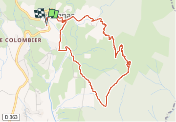

Length
6.1 km

Max alt
498 m

Uphill gradient
256 m
Km-Effort
9.5 km

Min alt
270 m

Downhill gradient
260 m
Boucle
Yes
Creation date :
2024-07-07 12:15:52.617
Updated on :
2024-07-07 15:01:56.084
1h53
Difficulty : Medium

FREE GPS app for hiking
 SityTrail
IGN / Geographical institutes
SityTrail Plus
The world is yours!
About
Trail Walking of 6.1 km to be discovered at Auvergne-Rhône-Alpes, Ardèche, Aubignas. This trail is proposed by pb07.
Positioning
Country:
France
Region :
Auvergne-Rhône-Alpes
Department/Province :
Ardèche
Municipality :
Aubignas
Location:
Unknown
Start:(Dec)
Start:(UTM)
629534 ; 4938423 (31T) N.
Comments