


2024-07-08_11h21m52_export_24_07_08_112146

oliviergau
User

Length
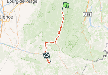
69 km

Max alt
1431 m

Uphill gradient
1548 m
Km-Effort
90 km

Min alt
292 m

Downhill gradient
1655 m
Boucle
No
Creation date :
2024-07-08 09:21:53.069
Updated on :
2024-07-08 09:21:52.755

FREE GPS app for hiking
 SityTrail
IGN / Geographical institutes
SityTrail Plus
The world is yours!
About
Trail of 69 km to be discovered at Auvergne-Rhône-Alpes, Drôme, La Chapelle-en-Vercors. This trail is proposed by oliviergau.
Positioning
Country:
France
Region :
Auvergne-Rhône-Alpes
Department/Province :
Drôme
Municipality :
La Chapelle-en-Vercors
Location:
Unknown
Start:(Dec)
Start:(UTM)
690684 ; 4982104 (31T) N.
Comments