


2024-07-08 autour de la Ville du Bois

Lucquiaud
User
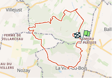

Length
10.4 km

Max alt
167 m

Uphill gradient
209 m
Km-Effort
13.2 km

Min alt
76 m

Downhill gradient
215 m
Boucle
Yes
Creation date :
2024-07-08 07:47:04.582
Updated on :
2024-07-08 11:14:03.432
3h26
Difficulty : Medium

FREE GPS app for hiking
 SityTrail
IGN / Geographical institutes
SityTrail Plus
The world is yours!
About
Trail Walking of 10.4 km to be discovered at Ile-de-France, Essonne, Saulx-les-Chartreux. This trail is proposed by Lucquiaud.
Positioning
Country:
France
Region :
Ile-de-France
Department/Province :
Essonne
Municipality :
Saulx-les-Chartreux
Location:
Unknown
Start:(Dec)
Start:(UTM)
446631 ; 5391152 (31U) N.
Comments