


Varennes Chabanne

JeanPierreNancy
User
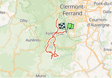

Length
54 km

Max alt
1003 m

Uphill gradient
1030 m
Km-Effort
68 km

Min alt
729 m

Downhill gradient
1025 m
Boucle
Yes
Creation date :
2024-07-08 12:18:01.825
Updated on :
2024-07-08 16:18:34.007
3h48
Difficulty : Difficult

FREE GPS app for hiking
 SityTrail
IGN / Geographical institutes
SityTrail Plus
The world is yours!
About
Trail Mountain bike of 54 km to be discovered at Auvergne-Rhône-Alpes, Puy-de-Dôme, Chanonat. This trail is proposed by JeanPierreNancy.
Positioning
Country:
France
Region :
Auvergne-Rhône-Alpes
Department/Province :
Puy-de-Dôme
Municipality :
Chanonat
Location:
Unknown
Start:(Dec)
Start:(UTM)
504251 ; 5061346 (31T) N.
Comments