Cantal_02_Puy-Mary_Peyre-Arse

pmg.griot
User
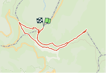

Length
10.1 km

Max alt
1786 m

Uphill gradient
597 m
Km-Effort
18.1 km

Min alt
1421 m

Downhill gradient
598 m
Boucle
Yes
Creation date :
2024-07-08 08:49:51.035
Updated on :
2025-05-01 19:28:32.343
4h06
Difficulty : Difficult

FREE GPS app for hiking
 SityTrail
IGN / Geographical institutes
SityTrail Plus
The world is yours!
About
Trail Walking of 10.1 km to be discovered at Auvergne-Rhône-Alpes, Cantal, Lavigerie. This trail is proposed by pmg.griot.
Positioning
Country:
France
Region :
Auvergne-Rhône-Alpes
Department/Province :
Cantal
Municipality :
Lavigerie
Location:
Unknown
Start:(Dec)
Start:(UTM)
475315 ; 4995449 (31T) N.
Comments