


Les crêtes de Font D'Urle

raymondfn
User
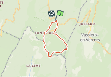

Length
9.6 km

Max alt
1564 m

Uphill gradient
289 m
Km-Effort
13.5 km

Min alt
1398 m

Downhill gradient
288 m
Boucle
Yes
Creation date :
2024-07-08 18:29:17.575
Updated on :
2024-07-08 18:31:07.731
3h03
Difficulty : Difficult

FREE GPS app for hiking
 SityTrail
IGN / Geographical institutes
SityTrail Plus
The world is yours!
About
Trail Walking of 9.6 km to be discovered at Auvergne-Rhône-Alpes, Drôme, Bouvante. This trail is proposed by raymondfn.
Points of interest


Positioning
Country:
France
Region :
Auvergne-Rhône-Alpes
Department/Province :
Drôme
Municipality :
Bouvante
Location:
Unknown
Start:(Dec)
Start:(UTM)
684146 ; 4975467 (31T) N.
Comments