


prapic basset saut du laire et retour

clintest
User
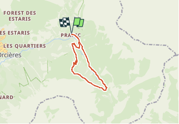

Length
10.6 km

Max alt
2069 m

Uphill gradient
534 m
Km-Effort
17.7 km

Min alt
1570 m

Downhill gradient
533 m
Boucle
Yes
Creation date :
2024-07-09 12:51:10.699
Updated on :
2024-07-09 12:51:47.851
4h01
Difficulty : Easy

FREE GPS app for hiking
 SityTrail
IGN / Geographical institutes
SityTrail Plus
The world is yours!
About
Trail On foot of 10.6 km to be discovered at Provence-Alpes-Côte d'Azur, Hautes-Alpes, Orcières. This trail is proposed by clintest.
Positioning
Country:
France
Region :
Provence-Alpes-Côte d'Azur
Department/Province :
Hautes-Alpes
Municipality :
Orcières
Location:
Unknown
Start:(Dec)
Start:(UTM)
291645 ; 4952296 (32T) N.
Comments