


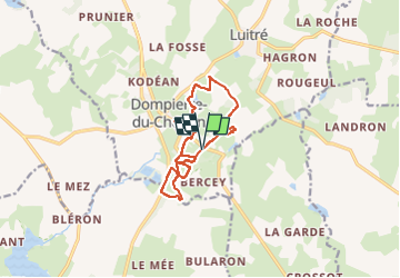
09/07/2024 - Dompierre & les Rochers de Saut Roland.Virtuel

babeth35
User

Length
11.1 km

Max alt
177 m

Uphill gradient
202 m
Km-Effort
13.8 km

Min alt
119 m

Downhill gradient
200 m
Boucle
Yes
Creation date :
2024-07-09 13:09:49.008
Updated on :
2024-07-09 13:22:00.274
3h08
Difficulty : Easy
3h08
Difficulty : Difficult

FREE GPS app for hiking
 SityTrail
IGN / Geographical institutes
SityTrail Plus
The world is yours!
About
Trail On foot of 11.1 km to be discovered at Brittany, Ille-et-Vilaine, Luitré-Dompierre. This trail is proposed by babeth35.
Positioning
Country:
France
Region :
Brittany
Department/Province :
Ille-et-Vilaine
Municipality :
Luitré-Dompierre
Location:
Dompierre-du-Chemin
Start:(Dec)
Start:(UTM)
638631 ; 5346886 (30U) N.
Comments